DJI 900MHz Data-Link w/Ground Control Software
DJI-DL900

This item is discontinued and no longer available for purchase. You may want to search our site for a similar item.
Note: Manufacturer does not allow coupons
FREE U.S. Shipping on orders of $99 or more*. See complete details >
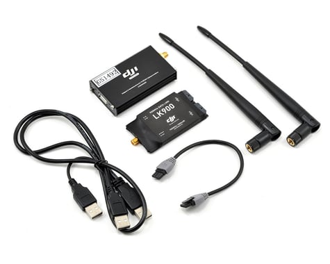
This is the DJI Innovations 900MHz Data-Link with included Ground Control Software. The DJI Innovations Data-Link was developed specifically for the purpose of BVR (Beyond Visual Range) aircraft operation, and its approximate 5-mile range makes it perfect for aerial photography, video and general surveillance. The Data-Link allows the user to eliminate the transmitter and use a laptop combined with the DJI Ground Control Station software to use a computer keyboard to fly, as well as perform repeatable autonomous waypoint flights, and point and click flying. This allows the user to worry less about the aircraft, and monitor critical flight data, or get that epic shot!
The Data-Link system provides the pilot with critical flight information in real time, including current altitude, GPS coordinates, air speed, angle of the aircraft, on-board battery voltage and signal quality of the wireless data link, all displayed on the laptop screen. The Click-2-Go mode allows the user to choose a point on the map, specify the altitude and flight speed, then simply “click" a button, and the aircraft will fly there on its own! Plus, while the user is monitoring the route on the Ground Control Station, the altitude, flight speed, and even the destination point can be changed on the fly, with the push of a button!
DJI Ground Control Station software enables 3D Map Way Point Editing, Flight Path Planning, Real time Flight State Feedback and Auto Takeoff and Landing. When used with the DJI Wookong-M or ACE ONE autopilot system, the DJI Ground Control Station not only ensures stable performance, but more importantly improved aircraft safety and simplified operation.
Features:
NOTE: The Data-Link must be used with either the Wookong-M or ACE ONE systems, combined with your laptop. Additional way points must be purchased separately.
This product was added to our catalog on August 27, 2013